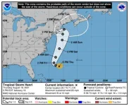
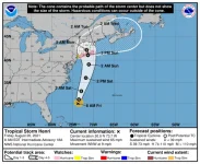
The storm is also a snail, which means longer times under the influence. For us on the track above the landfall, it's a great bonus, as the stall will bust the storm up so our involvement will be with a mild Tropical Storm IF things don't change for the worse...
Current wind speed and direction forecasts for my hood are low enough to belay any thoughts of hauling the boat and wide-spread removal of lawn/patio furniture, etc. Probably just remove the pergola top, put the glass patio table and chairs upside down on the lawn, move the kayaks up off the float to the dock and triple tie down the boat.