Jturano1121
New Angler
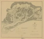
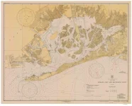
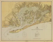
I love comparing old charts, especially of Jamaica Bay where I grew up fishing. Here are four of them from years: 1910, 1926, 1934 and 1954. The changes are amazing. In the oldest chart you can see there is no East Rockaway Inlet and that Jamaica Bay connects to the Bay of Far Rockaway. In the 1926 chart you can see Rockaway Point before the Jetty was built circa 1933. In the 1934 chart you can see how far the jetty extended originally and meant to trap westward moving sands from collecting and closing off Rockaway Inlet. By 1954, the Bay sort of looks like its present shape, with the Marine Parkway Bridge but notice the name of JFK Airport. It’s really something to behold and I hope you enjoy it as much as I do.

 ,,,,,,,, how are you and the family ,,,,hope all is well. As you mite know we live in fla
 for the last 4+ years,,,,,,,,,,we left the mojoe skiff behind
  ,,,,,,,,,,,,,,,
 Maureen the bay hasn’t been the same ever since you guys left but always here in spirit

") ,,,,,,,,,,
,,,,,,,,,,