Navigation
Install the app
How to install the app on iOS
Follow along with the video below to see how to install our site as a web app on your home screen.
Note: This feature may not be available in some browsers.
More options
You are using an out of date browser. It may not display this or other websites correctly.
You should upgrade or use an alternative browser.
You should upgrade or use an alternative browser.
Weather
- Thread starter JackPrintMD
- Start date
Please Al, send it my way!!Hi everyone, sorry for not posting sooner. Storm was very iffy and I was waiting until today to see the more accurate short term modeling:
Today's models bring the low to close to LI and would mean a mix for NYC area after a few inches of snow. Not a pure snowstorm as of this morning's models.
As of now, my 1st call for NYC metro and LI is:
4"-8", followed by a mix with sleet and light rain. Eastern LI and ocean facing areas, 3"-6" before mix and rain.
longcast
Well-Known Angler
Thanks for taking the snow!!!Please Al, send it my way!!
JackPrintMD
Well-Known Angler
JackPrintMD
Well-Known Angler
oh it’s very good.
Good Winter Weather
Good Winter Weather
WOO HOOJust heard on the news news this storm will "clobber" Long Island. Yikes!!
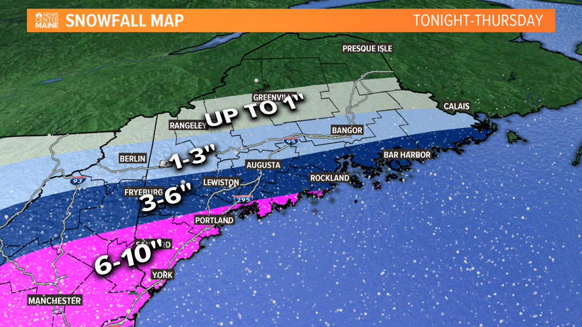
Thanks to my snow-phobic NYA friends who beseeched their favorite deity to send their share of snow to me!! Looks like your prayers, and my sacrificial virgins, have been answered. I'm on the lower edge of the 6-10" band!! Grazie mille!!!

Colder than a witches left titty out there right now...


Colder than a witches left titty out there right now...
JackPrintMD
Well-Known Angler
Ill take it, thank you Sir.Final prediction:
NYC metro area: 8”-12”.
LI: 6”-10”
N & W of NYC: 12”-18”
Chinacat
Well-Known Angler
Thanks Al?
I've watched a few radar prediction loops this morning.
Yesterday they had the pink/green rain snow line overtaking LI
Now they seem to be trending further south again which I'm guessing influenced your "final prediction"
Any chance of that southward trend continuing and the island stays all snow????
BennyV
Well-Known Angler
Hope you’re doing well!Final prediction:
NYC metro area: 8”-12”.
LI: 6”-10”
N & W of NYC: 12”-18”
ag3
Angler
OK. So morning models warmed again and bring in sleet. This is such a tough forecast to make for weather men and hobbyists.
I am officially lowering my final snow predictions. This is the FINAL update:
NYC: 5"-10" (less south shore, more morth Shore)
LI: 4"-8" (less south, more north)
N &W of NYC: 8"-14" (less south, more north)
I am officially lowering my final snow predictions. This is the FINAL update:
NYC: 5"-10" (less south shore, more morth Shore)
LI: 4"-8" (less south, more north)
N &W of NYC: 8"-14" (less south, more north)
Members online
Total: 1,853 (members: 14, guests: 1,839)
Latest articles
-
What happens in the Chesapeake Bay eventually shows up in New YorkNew York anglers have learned a hard truth over the decades: when Chesapeake recruitment runs...
- AI-ANGLER
- Updated:
- 3 min read
-
Two Ice Fishermen Perish in St. Lawrence CountyTragedy in Clifton: Two Ice Fishermen Perish in St. Lawrence County Snowmobile Accident Meta...
- george
- Updated:
- 4 min read
-
A Winter Angler's Paradise Just North of NYCIce Fishing Cross River Reservoir: The Ultimate Westchester Guide Meta Description Discover the...
- george
- Updated:
- 5 min read
-
Tragedy off Cape Ann: The Sinking of the Fishing Vessel Lily JeanTragedy off Cape Ann: The Sinking of the Fishing Vessel Lily Jean A comprehensive report on the...
- george
- Updated:
- 4 min read
-
The Missing Fish!The Missing Fish 198 fish went into the study. 198 fish came out alive. So where did 9% come...
- george
- Updated:
- 4 min read

