Navigation
Install the app
How to install the app on iOS
Follow along with the video below to see how to install our site as a web app on your home screen.
Note: This feature may not be available in some browsers.
More options
You are using an out of date browser. It may not display this or other websites correctly.
You should upgrade or use an alternative browser.
You should upgrade or use an alternative browser.
HENRI
- Thread starter Bassmaster
- Start date
- Status
- Not open for further replies.
ag3
Angler
Not a meteorologist but I think it will get a ton of energy and hit as a strong cat 1/cat 2.
Hope not.
No sense of urgency in the air. Guess everyone forgot Sandy that wasn't even a hurricane!!!!
Sandy was a Category 3 hurricane that phased with an ULL to form a superstorm. It had Category 3 pressure, which caused category 3 storm surge and Category 1 winds.
This storm is nowhere near Sandy. Not even close. Sandy was a beast.
ag3
Angler
L
Landfall is Hamptons to Rhode Island. The majority of models miss LI now and landfall near Block Island and RI.
The only reason why LI is in play is because the Euro has a Hamptons landfall. But it’s on its own and in my experience never pick the outlier model and use the consensus.
This is why I’m going with a Block Island and RI landfall.
Landfall between smithtown and Montauk
Landfall is Hamptons to Rhode Island. The majority of models miss LI now and landfall near Block Island and RI.
The only reason why LI is in play is because the Euro has a Hamptons landfall. But it’s on its own and in my experience never pick the outlier model and use the consensus.
This is why I’m going with a Block Island and RI landfall.
Huh???During Sandy, boats with plug out sank at drydock.
Im guessing drydock got floodedHuh???
Avenger
Well-Known Angler
Huh???
On the hard.
Boats that were on the hard got floated and then sank because the plugs were out.
Bassmaster
Well-Known Angler
Torrential downpours in queens now
Bassmaster
Well-Known Angler
Flood advisory for the five boroughs of nyc 1-2 inches of rain.
Bassmaster
Well-Known Angler
Flash flooding is likely
Ahh...got it.On the hard.
Boats that were on the hard got floated and then sank because the plugs were out.
I doubt that'll happen on my street but with the way it's raining right now ya never know
longcast
Well-Known Angler
Thank you for your updates!!!Quick update. Models have shifted east the last 24 hours. And weaker.
I don’t want to downplay it, but it’s nowhere near as bad as it looked 2-3 days ago.
The landfall zone right now is Hamptons to Block Island and east. I would favor Block Island.
The biggest threat now is flooding rains. 3”-8” widespread.
Things can shift quickly so I will update once more time if I see drastic changes.
In terms of intensity, I don’t see this stronger than a high end Tropical Storm or weak Category 1. Favoring a Tropical Storm at landfall. Sustained winds 50-65mph with gusts to 70-80.
Bassmaster
Well-Known Angler
Flash flood warning for manhattan
Bassmaster
Well-Known Angler
|
Bassmaster
Well-Known Angler
Flash flood warning Bronk Nassau queens
I put away all my umbrellas, pool stuff, all my yard ornaments. filled up a couple of gas cans for the genny and both vehicles, charged up everything that would need charging, tied a tarp down with multiple lines over the hardly ever used boat, tied outdoor chairs to a wrought iron bench, upended picnic benches, etc etc. Truck onto driveway. Of course its going to be east of Montauk, lol.
Bassmaster
Well-Known Angler
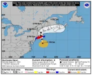
| ...A DANGEROUS STORM SURGE, HURRICANE CONDITIONS, AND FLOODING RAINFALL ARE EXPECTED IN PORTIONS OF THE NORTHEAST UNITED STATES BEGINNING LATE TONIGHT OR ON SUNDAY... |
| 11:00 PM EDT Sat Aug 21 Location: 38.6°N 71.0°W Moving: N at 21 mph Min pressure: 987 mb Max sustained: 75 mph |
Bassmaster
Well-Known Angler
WhatKnot
Well-Known Angler
Much more dramatic in Astoria now.Good rain in Astoria, but nothing too dramatic. We will see.
- Status
- Not open for further replies.
Latest articles
-
Recreational Anglers Deserve an ApologyI've Been Saying This All Along: Recreational Anglers Deserve an Apology The data is finally in...
- george
- Updated:
- 6 min read
-
Abu Garcia's Beast SeriesAbu Garcia's Beast Series: Revolutionary Equipment for the Modern Swimbait Revolution October...
- george
- Updated:
- 6 min read
-
World's Lightest Spinning ReelGame-Changer or Gimmick? The Daiwa LUVIAS ST Claims to Be the World's Lightest Spinning Reel An...
- george
- Updated:
- 4 min read
-
New York Fluked Itself!Fluke Management in 2025: Regulators Got It Wrong Halfway through this season New York anglers...
- george
- Updated:
- 2 min read
-
Hunting Stripers and Blues from Rockaway Beach to Moriches InletThe Western Run: Hunting Stripers and Blues from Rockaway Beach to Moriches Inlet By: A Die-Hard...
- george
- Updated:
- 10 min read

